Geography
UPSC Syllabus for Geography
Changes in critical geographical features (including water bodies and ice-caps) and in flora and fauna and the effects of such changes.
2022
Meaning of colour-coded weather warnings for cyclone prone areas given by IMD
- Green code: there is no likelihood of adverse weather conditions – no advisories are released
- Yellow alert: cyclone is likely to form or move towards a region - intensity of the storm is not severe - cautionary warning to stay prepared.
- Orange alert: cyclone is expected to make landfall in a region with wind speeds of 60-100 km/hour - likely to cause moderate damage and could disrupt normal life.
- Red alert: Issued when a cyclone is expected to make landfall with wind speeds of over 100 km/hour - likely to cause severe damage to infrastructure, cause flooding, and disrupt normal life.
Characteristics of primary rocks
- They are crystalline and without any organic remains on them.
- The characteristics of primary rocks depend on the composition of the magma or lava from which they form, as well as the conditions under which they solidify.
Intrusive Igneous Rocks:
- Formed from magma that cools and solidifies beneath the Earth's surface.
- Usually coarse-grained and have a crystalline texture.
- Darker and denser
E.g.: granite, diorite, and gabbro.
- Formed from lava that cools and solidifies on the Earth's surface.
- Usually fine-grained and have a glassy or vesicular texture.
- Lighter and less dense
E.g.: basalt, andesite, and rhyolite.
Forces that influence ocean currents
- Wind: trade winds, westerly, and polar easterlies creates surface currents that are driven by the frictional drag of the wind on the water's surface
- Temperature and Salinity: they determine the density of seawater, which affects the vertical movement of ocean currents. When water is cold and/or salty, it becomes denser and sinks, while warmer and/or less salty water rises.
- Coriolis Effect: The rotation of the Earth causes the Coriolis effect, which deflect water, to the right in the northern hemisphere and to the left in the southern hemisphere. This effect plays a significant role in the direction of ocean currents.
- Shallow sea zones where cold and warm water currents mix well making them great breeding grounds for fishes. E.g. Grand Bank (Atlantic) where Gulf stream (warm) and Labrador (cold) Currents meet.
- Warm ocean currents can support fish species that thrive in warmer waters, while cold ocean currents can support fish species that require colder waters.
- Fishermen also use ocean currents to their advantage by following them to locate schools of fish. This practice, known as drift fishing or drift netting.
The distribution of rubber producing countries
- Southeast Asia, specifically Thailand, Indonesia, Vietnam followed by China and India, are the largest producers of natural rubber,
- African countries such as Côte d'Ivoire, Liberia, and Nigeria.
- Latin America - Brazil and Mexico are the leading rubber producing countries.
- Deforestation: Rubber trees are typically grown in monoculture plantations, leading to deforestation and habitat destruction. This can have significant impacts on biodiversity and carbon storage in the affected areas.
- Soil Degradation: Intensive cultivation of rubber can lead to soil degradation and erosion, reducing soil fertility and agricultural productivity.
- Water Pollution: Rubber plantations can lead to increased water pollution due to the use of pesticides and fertilizers, as well as runoff from the plantations. This can have negative impacts on aquatic ecosystems and public health.
- Greenhouse Gas Emissions: The production of rubber is a significant source of greenhouse gas emissions, particularly due to deforestation and land use change.
- Labour Issues: Rubber plantations often rely on low-paid and poorly treated workers, leading to issues such as child labour, low wages, and poor working conditions.
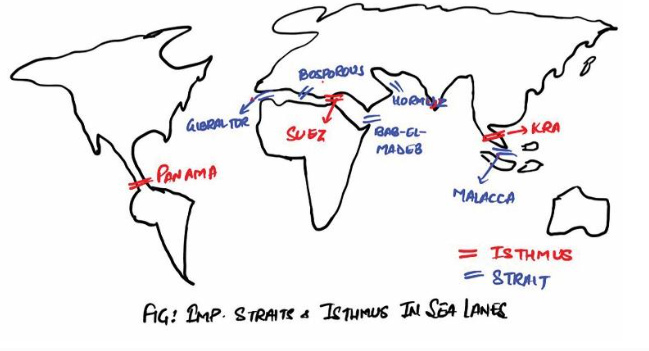
Significance of straits and isthmuses in international trade
- Reduced transportation costs: By offering the shortest and most efficient transportation routes, straits and isthmuses can significantly reduce transportation costs and enable the movement of goods and people across regions.
E.g.: Panama Canal connecting Atlantic and Pacific Oceans through Panama Isthmus - Increased trade: The presence of strategic transportation routes can increase the volume and diversity of trade between different regions of the world, promoting economic growth and development.
E.g.: Suez Canal has 30% global container traffic. - Geopolitical significance: Control over straits and isthmuses can provide strategic advantages in global politics and trade, and have historically been sites of conflict and competition between different nations.
E.g.: Strait of Malacca connecting Pacific and Indian Ocean - Energy security: Strait of Hormuz connects Oil rich middle east with rest of the world. Important for India’s energy security.
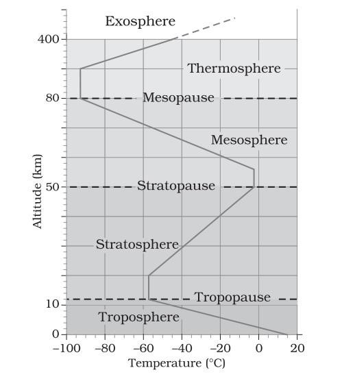
- Role in hydrological cycle:
- Troposphere has the most atmospheric water vapour, and where most of the Earth's precipitation originates.
- As warm, moist air rises from the surface, it cools and condenses, forming clouds and precipitation. These processes are critical for the development of storms, hurricanes, and other weather systems that can have significant impacts on human societies.
- Role in atmospheric circulation:
- Troposphere is where most the Earth's weather occurs, and it is characterized by complex patterns of air movement and pressure systems.
- These patterns can drive the movement of air masses across large distances, leading to the development of weather systems such as fronts, cyclones, and anticyclones.
- Role in determining the Earth's climate:
- As greenhouse gases such as carbon dioxide and methane accumulate in the atmosphere, they trap heat from the Sun and warm the planet's surface.
- This warming effect is most pronounced in the troposphere, where temperatures increase with altitude due to the absorption of solar radiation.
Natural resource potentials of ‘Deccan Trap’
- Minerals: Minerals such as iron ore, manganese, copper, and precious metals such as gold and silver. The region is also home to large deposits of bauxite, chromite, and nickel.
- Water resources: Several major rivers such as the Godavari, Krishna, and Cauvery, which are fed by the Deccan Traps' extensive network of groundwater aquifers.
- Agricultural potential: The Deccan Traps have rich soil (e.g. Black soil) and a favourable climate for agriculture crops such as cotton, sugarcane, groundnuts, and pulses.
- Geothermal energy: The Deccan Traps' extensive network of fissures and cracks has the potential to harness geothermal energy through geothermal hotspots.
Potential for Wind energy in India
- Long coastline and warm tropical climate – suitable for wind farms
- Large Hilly regions – India’s estimated wind potential at 120m height is 695 GW
- Government push for renewable energy – India targets 50% renewable energy mix – wind plays an important role.
- Limited availability of suitable land: mainly due to competition with other land uses such as agriculture and urbanization.
- Inadequate transmission infrastructure: potential areas are remote - challenge connecting them to the grid
- Regulatory issues: such as delays in land acquisition, and clearances
- Competition from solar energy: declining cost of solar energy has made it a more attractive option for developers.
Globalization is the process of increased interconnection. It seeks to integrate the world in political, economic, social, religious, cultural and technological aspects.
Relationship between globalization and new technology in a world of scarce resourcesPositive consequences
- Globalization has led to increased trade and investment, which has facilitated the transfer of technology and know-how to developing countries like India. Increased global interdependency – reduced conflict.
- This has created new opportunities for economic growth and innovation,
- New technologies, such as renewable energy and digital communication, have also played a key role in shaping India's development trajectory.
- The unequal distribution of resources and power has created winners and losers.
- In India, this has led to growing disparities between urban and rural areas, as well as between different socio-economic groups.
Eg.: exploitation of cheap labour from India - Additionally, the exploitation of natural resources and the environmental impact of industrialization have raised concerns about sustainability.
The challenge for India and other countries is to find a balance between economic growth and social and environmental sustainability, while also addressing the inequalities that can arise from globalization and new technology.
2021
A landslide is defined as the movement of a mass of rock, debris, or earth down a slope. Various reasons can cause landslide.
Causes of landslides in the Himalayan region and Western GhatsHimalayan region
- Landslides occur primarily due to geological instability caused by tectonic activity of the plate moving up.
- The Himalayas are young mountains with active tectonic activity, and the rocks are relatively unstable and loose.
- The steep and sharp slope in the Himalayas accelerate landslides
- Large fast-moving rivers like Ganga and Brahmaputra erode mountainous regions accelerating landslides
- Heavy rainfall during the monsoon season destabilises the slopes
E.g.: Almora, Pithoragarh, Rudraprayag etc.
- Primarily caused by human activity and deforestation.
- Have a relatively stable geology, but the indiscriminate felling of trees and the construction of roads and buildings on the slopes has weakened the soil structure
- Receive heavy rainfall during the monsoon season, which can further exacerbate the landslides.
E.g.: Ratnagiri, Satara, Idukki etc
A volcano is a rupture in the crust of a planetary-mass object, such as Earth, that allows hot lava, volcanic ash, and gases to escape from a magma chamber below the surface.
Global occurrence of volcanic eruptions in 2021- La Soufriere eruption in St. Vincent and the Grenadines - in April 2021, this volcano erupted for the first time in over 40 years, forcing thousands of people to evacuate.
- Mount Nyiragongo eruption in the Democratic Republic of Congo - in May 2021
- Fagradalsfjall eruption in Iceland - March 2021
- Taal volcano: Manila, experienced eruptions in 2021.
- Plumes of volcanic ash can spread over the large areas of the sky, reducing visibility.
E.g.: Raung eruption in Indonesia, causing disruptions to air travel - Often accompanied with events of volcanic lightning.
- Volcanic ash reflects incoming solar radiation leading to a localised cooling effect in the temperature.
E.g.: Mt. Krakatau brought mini-ice-age. - The volcanic ashes are known to increase the soil productivity of the region.
- Carbon di-oxide and fluorine gas can get collected in volcanic ash, and can pollute the regional environment
- Stimulate earthquakes in the region.
Alignment of major mountain ranges has a significant impact on local weather conditions.
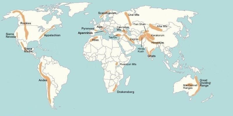 Himalayas
- Located in South Asia, act as a barrier to cold winds from Central Asia, resulting in a relatively warm and humid climate in the region.
- Cause the Indian Monsoon, which brings heavy rainfall to the Indian subcontinent,
- Role in the hydrology of the region, as several major rivers like the Ganges, Brahmaputra, and Indus originate from these mountains.
- Located in South America, run parallel to the west coast of the continent, creating a rain shadow effect on the eastern side.
- As moist air from the Pacific Ocean rises and cools while crossing the mountains, it releases precipitation on the western side, leaving the eastern side dry.
- located in North America, cause a rain shadow effect on the Great Plains to the east.
- Moist air from the Pacific Ocean rises as it crosses the Rockies, releasing precipitation on the western side and leaving the eastern side dry.
- Affect local weather patterns, as their elevation results in temperature variations, especially in winter.
- located in Europe, they create a barrier to cold winds from the north, resulting in a relatively warm and humid climate in southern Europe.
- In contrast, northern Europe experiences colder temperatures and higher precipitation due to the barrier effect of the Alps.
- located in Russia, create a similar barrier effect, preventing cold winds from Siberia from reaching Europe.
- As a result, Europe experiences relatively mild weather compared to other regions at similar latitudes.
Impact of melting Arctic ice
Weather
- Affects the path of jet streams – makes them slower and weaker – colder vortexes in USA.
- Reduced rainfall during Monsoons in India.
- Opening of North Sea route for global trade, saving both time and cost.
- Reduced opportunities for the native population for subsistence hunting, fishing and herding Melting of glaciers in Antarctica
Weather
- Lead to slowdown of Atlantic Meridional Overturning Circulation – this will disrupt the Gulf Stream which causes colder winters and warmer summers in North America. This will also cause extreme weather phenomenon in Europe.
- The warming of Antarctica Circumpolar Current can aggravate the effects of global warming.
- As a result of sea-level rise, storm surges become more prevalent
- Increased coastal erosion due to sea level rise – disrupt coastal economy, especially tourism
- Strengthening of El-Niño: Antarctic ice melting could cause strengthening El Nino event which may bring large scale drought in Indian peninsula putting large population into stress.
Multi-dimensional implications of uneven distribution of mineral oil in the world
- Political instability and conflicts: Countries that are rich in oil reserves are often targeted by foreign countries for their resources.
E.g.: the conflicts in the Middle East, particularly in Iraq, are partly due to its vast oil reserves, leading to intervention by foreign powers. - Economic implications: Countries that are dependent on oil exports for their economy are vulnerable to fluctuations in global oil prices, leading to economic instability. Conversely, countries that are net importers of oil face increased costs and economic burden, leading to inflation and slower economic growth.
- Balance of Trade: The un-even distribution of the mineral oil resources affects the balance of trade This in turn affects the Foreign-exchange reserves of the country.
E.g.: India having trade deficit with UAE, Saudi Arabia etc - Social implications: Countries with abundant oil resources often suffer from resource curse, where the economy becomes too reliant on oil exports, leading to neglect of other sectors of the economy and widening income inequality.
- Environmental implications: The extraction process often results in the destruction of natural habitats and pollution of the environment, leading to the degradation of ecosystems and harm to human health.
- Energy Security: The un-even distribution of the mineral energy resource has led to high degree of energy insecurity in the oil deficient countries. It also, directly affects their strategic autonomy
Reasons for low contribution mining industry to Gross Domestic Product
- Minerals are in forested tribal areas. Democratic polity with a mandate for welfare creates conflicting priority of mineral exploitation and tribal development
- Many mines in India are still operated manually, which results in lower productivity and higher costs.
- The lack of proper infrastructure, such as roads, railways, and ports, makes it difficult to transport minerals to the markets.
- Strict environmental regulations (Red tapism) and community resistance to mining projects. Many mining projects face accusations of such as land degradation, air and water pollution, and displacement of local communities.
- Monopoly of PSUs: results in unproductive usage of assets. For example, coal India’s monopoly in coal sector.
Environmental implications of reclamation of water bodies into urban land use
- Reduction in the availability of water for irrigation, drinking, and other essential purposes. E.g. For example, encroachment of water bodies in West Bengal have led to high level of arsenic pollution.
- Loss of biodiversity and ecological services that these water bodies provide. E.g. loss of fish and water birds - reclamation of Hussain Sagar Lake in Telangana, have increased the BOD to 116 mg/l. It is detrimental for not only aquatic species but also for aerial fauna
- Result in soil erosion, flooding, and groundwater depletion. g. recurrent Mumbai floods, which lost 71% of its wetlands between 1970 to 2014.
- Environmental hazards: Water reclamation for urban land use in the coastal areas may aggravate the incidents of earthquakes , due to soil liquefaction and land subsidence
India is considered as a sub-continent
- Distinct geographic features: It is a large landmass separated from the rest of Asia by the Himalayan Mountain range in the north, the Hindu Kush Mountains in the northwest, and the Arakan Yoma hills in the east.
- Cultural diversity: These natural barriers have resulted in India's isolation and distinct cultural and linguistic diversity.
- Due to its large size
- India has a wide range of climate zones, from the tropical rainforest in the south to the arid desert in the northwest, which further contributes to its sub continental status.
- The Indian subcontinent also has a unique geological history, with the collision of the Indian and Eurasian tectonic plates resulting in the formation of the Himalayas and the Deccan Plateau.
- India's history and culture have also contributed to its sub continental identity. India has a rich history of diverse kingdoms and empires, and its religions, including Hinduism, Buddhism, and Islam, have shaped its cultural heritage.
India remained the world’s top source destination with a share of 55% in the global IT and ITeS market. The IT industry accounts for 8% of Indian GDP which had an exponential growth after the economic reforms in 1991-92.
Major IT industrial locations are Hyderabad, Bangalore, Chennai etc
Main socio-economic implications arising out of the development of IT industries in major cities of India- Employment generation: creation of new job opportunities, particularly for young professionals. IT firms employ many people with diverse backgrounds and skill sets, thereby contributing to the growth of the middle class.
- Increase in income levels: The salaries offered by IT firms have helped to increase the income levels of employees and have contributed to the overall growth of the economy.
- Emergence of new urban spaces: particularly in cities like Bangalore, Hyderabad, Pune, and Chennai. These cities have become major hubs of technology and innovation, attracting people from across the country and the world.
- Impact on real estate: This has led to a rise in property prices, making housing unaffordable for many people.
- Technological advancement: helped development of new technologies, which have had a positive impact on various sectors, including healthcare, finance, and education.
- Impact on the environment: The IT industry is a major consumer of energy, which has contributed to environmental degradation - increase in traffic congestion and pollution in major cities.
2020
Far-reaching impacts of Melting of glaciers on India's water resources
- Reduced water availability: there will be a temporary increase in the flow of water in the rivers. However, in the long term, the reduced volume of glacial ice will result in reduced water availability in the dry season, when water demand is highest.
- Increased risk of flooding and sea level rise: as there will be a higher volume of water in the rivers during the monsoon season.
- Increased water insecurity: reduced availability of water due to melting glaciers could exacerbate water insecurity in India.
- Impact on agriculture: reduced availability of water due to melting glaciers could have a significant impact on crop yields and food security – increased groundwater extraction.
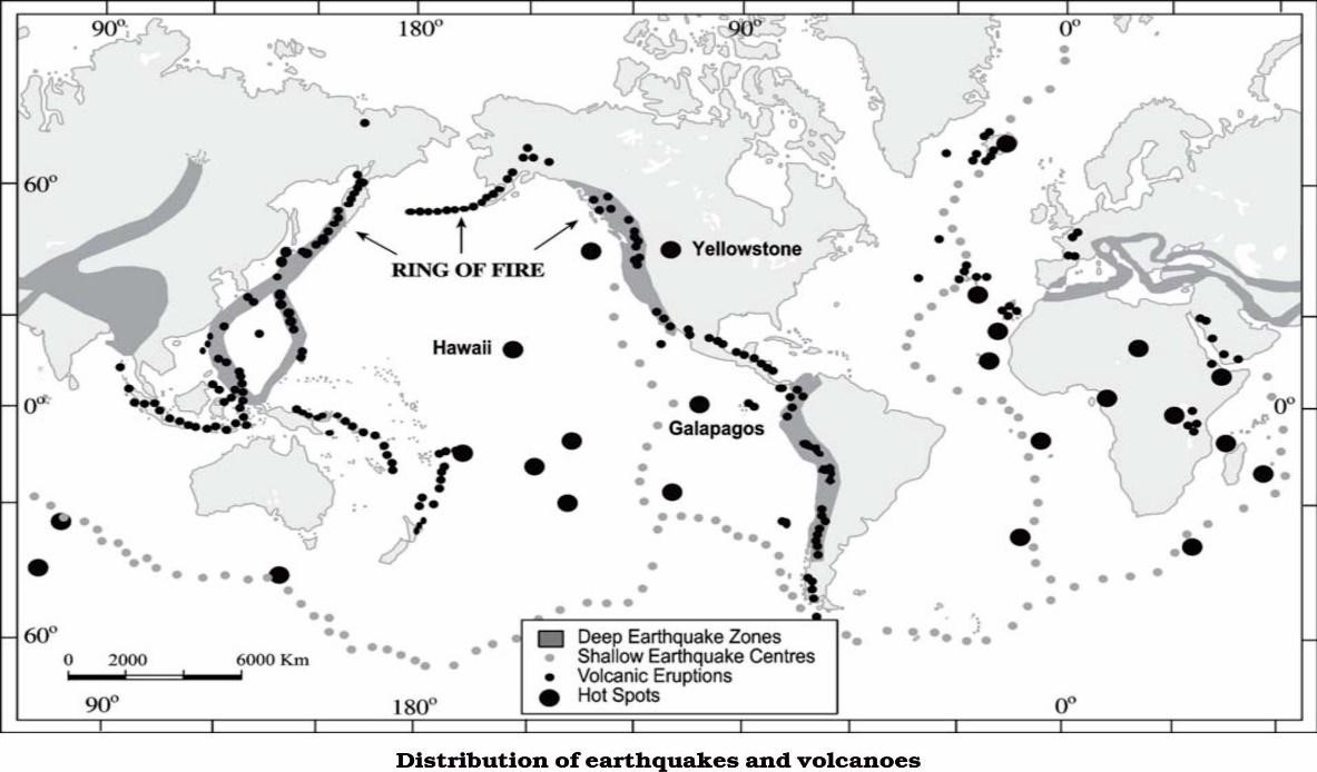
Geophysical characteristics of Circum- Pacific Zone
- Plate boundaries: located at the intersection of several tectonic plates, including the Pacific Plate, the North American Plate, and the Eurasian Plate - highly susceptible to earthquakes and volcanic activity.
- Volcanoes and hot spots: home to hot spots, areas deep within mantle from where heat rises to form some of the world's most active volcanoes, including Mount Fuji in Japan, Mount St. Helens in the United States, and Mount Pinatubo in the Philippines.
- Earthquakes: The region is also known for its frequent and powerful earthquakes, which are caused by the movement of tectonic plates. E.g. 2011 Fukushima earthquake in Japan,
- Tsunamis: The high level of seismic activity can also lead to the formation of tsunamis, which can cause widespread damage and loss of life.
Process of desertification does not have climate boundaries
- Sahel region: which lies between the Sahara Desert and the savannah, has experienced significant desertification due to a combination of droughts, overgrazing, and unsustainable farming practices.
- Mediterranean region: Parts of the Mediterranean region, such as southern Spain and Italy, have also experienced desertification due to a combination of overexploitation of natural resources, climate change, and unsustainable land use practices.
- Australia: due to its arid climate and susceptibility to droughts, as well as the impact of introduced species and land use changes.
- Central Asia: The Aral Sea region in Central Asia has experienced significant desertification due to the diversion of rivers for irrigation, leading to the drying up of the sea and the loss of vegetation
Factors responsible for present location of iron and steel industries away from the source of raw material
- Technological Advancements: Technological advancements in iron and steel production have reduced the reliance on proximity to raw material sources. Modern techniques such as pelletization, sintering, and improved blast furnace operations allow for the efficient utilization of raw materials, reducing the need to be located near the source.
Eg.: Japan - Access to Energy Resources: Iron and steel production requires significant energy inputs. Industries may choose to locate near energy sources, such as coal fields or power plants, to ensure a reliable and cost-effective energy supply.
- Transportation Infrastructure: The development of transportation infrastructure, including railways, roads, and ports, enables the movement of raw materials over long distances. Improved logistics and transportation networks make it feasible to transport raw materials from distant sources to manufacturing centres.
E.g.: United States - Market Accessibility: Industries often locate near consumer markets to reduce transportation costs and gain a competitive advantage. By situating steel plants closer to demand centres, companies can streamline their supply chains and respond more efficiently to market demands.
E.g.: Tata steels - Environmental Regulations: Environmental concerns and regulations play a role in the location of iron and steel industries.
ILR as viable solution to the multi-dimensional inter-related problems of droughts, floods and interrupted navigation
- Drought – moving water from water surplus regions seasonally to water deficit regions
- Floods – move excess flood waters to another area
- Navigation – help maintain sufficient water flow in rivers – allow movement of river vessels, reduces stress on road and rail medium.
- Critics argue that the project may lead to over-extraction of water from the rivers, which could worsen the water scarcity problem in the long run.
- May lead to the destruction of natural habitats, loss of biodiversity, and displacement of local communities.
- Possible negative impacts on the livelihoods of millions of people who depend on the rivers for their survival. The project may disrupt traditional fishing and farming practices and displace indigenous communities who have lived along the riverbanks for generations.
- High cost and potential economic inefficiency. The project is expected to cost billions of dollars and may require extensive infrastructure, including dams, canals, and tunnels - cost of transporting water from one region to another may be higher than the cost of conservation and management of local water resources.
Causes of urban flooding in India
- The unregulated growth of cities has led to the destruction of natural water bodies like lakes, wetlands, and rivers - reduced the capacity of the cities to absorb rainwater.
- Increase in impervious surfaces like concrete, asphalt, and buildings - increase in surface runoff, further exacerbating the problem of flooding.
- Climate change causes extreme weather events like heavy rainfall, cyclones, and storm surges to become more frequent and intense, leading to more severe flooding.
- Poor urban planning and infrastructure - inadequate drainage system, lack of proper solid waste management, and encroachment of natural water bodies have made the cities more vulnerable to flooding.
- Need for integrated water management strategies - conservation and restoration of natural water bodies, implementation of green infrastructure, and the promotion of sustainable urban planning.
- Need to invest in better urban infrastructure, including the development of a comprehensive drainage system, improving solid waste management, and upgrading the urban water supply system.
- Need for more effective disaster management systems - early warning systems, emergency response plans, and evacuation plans.
- Need for greater public awareness and community involvement in flood risk reduction and preparedness.
Regional variation in development of solar energy
- The states of Gujarat, Rajasthan, and Maharashtra, for example, have made significant progress in the development of solar energy. Gujarat has the highest installed solar power capacity in the country, with around 5.5 GW of installed capacity.
- Other states, however, have been slower to adopt solar energy. The north-eastern states, for example, have a low potential for solar energy due to their geographical location and frequent cloud cover - with only around 250 MW of installed capacity as of 2021.
- Difference in policy frameworks and incentives across state Some states offering incentives such as tax exemptions and subsidies for solar power projects. In contrast, other states have been slow to adopt such policies.
- Difference in the availability of land and infrastructure for solar power projects. States with a larger availability of suitable land and infrastructure have been able to develop solar power projects more easily.
- Environmental challenges: conflict with local communities
To address the regional variations, government has launched several initiatives, such as the National Solar Mission and the Solar Park Scheme - by offering incentives, simplifying regulatory processes, and providing support for the development of solar power projects.
Thus, to fully realize the potential of solar energy in India, there is a need for consistent policy frameworks and incentives across states, as well as the availability of suitable land and infrastructure for solar power projects.Status of forest resources
- According to the India State of Forest Report (ISFR) 2019, the total forest and tree cover in India has increased to 56% of the total geographical area of the country.
- But is still lower than the National Forest Policy's target of achieving 33% forest cover in the country.
- Forests act as a natural stabilizing agent for the climate as they regulate the carbon cycle significantly.
- Forests are the only unique, safe and inexpensive carbon capture and storage technology that is naturally available at scale with the potential to neutralize global CO, concentrations.
- Carbon sequestration through photosynthesis
- Deforestation, and unsustainable forest management practices
- Human activities such as agriculture, mining, and infrastructure development.
- Climate change - rising temperatures, changing precipitation patterns, and increased frequency and intensity of extreme weather events leading to forest fires, pests, and diseases.
- Forests act as carbon sinks, absorbing and storing carbon dioxide from the atmosphere, and thereby helping to mitigate climate change.
- Deforestation and forest degradation contribute to greenhouse gas emissions, exacerbating climate change.
- Perform crucial role in regulating the water cycle, influencing rainfall patterns, and maintaining water availability. Degradation of forest ecosystems can lead to reduced water availability, increased soil erosion, and land degradation, affecting agriculture and food security.
- Global warming has increased calamities like soil erosion and tidal floods – loss of mangrove forests, which acted as natural barriers, increases the destruction potential of such events.
2019
Impacts of global warming on coral reefs
- Warm ocean leads to coral bleaching, where the corals lose their symbiotic relationship with zooxanthellae algae - leads to the death of corals.
E.g.: Bleaching observed in the Great barrier reef of Australia.
- The temperature of oceans regulates mineral contents such as magnesium and calcium – mineral imbalance causes the corals are unable to utilise them and survive.
- Ocean acidification - when carbon dioxide from the atmosphere dissolves in seawater making water acidic - difficult for corals to build their skeletons, which are made of calcium carbonate.eg. Corals of Maldives
E.g. Collapse of coral colonies in Caribbean islands due to ocean acidification. - Thermal stress reduces the immunity of corals causes infections.
E.g. Yellow band disease in corals of Thailand
Causes for mangrove depletion
- Deforestation: Mangrove wood is highly valued for its strength and durability, and is used in construction and boat building. Mangrove forests are also being cleared for shrimp and fish farming
- Pollution: affect the growth and health of mangrove forests
- Coastal development - lead to the destruction of mangrove habitats
- Climate change, including sea level rise and changes in temperature and precipitation patterns
- Provide important nursery habitats for many species of fish and invertebrates
- provide critical protection against storms and coastal erosion.
- Role in carbon sequestration and the regulation of climate
- Ecotone and area of so many edge species
Strategy of regional resource-based manufacturing help in promoting employment in India
- For example, the development of the textile industry in Gujarat, Maharashtra, and Tamil Nadu has led to the creation of many jobs in these regions.
- Similarly, the availability of iron ore in Jharkhand and Chhattisgarh has led to the growth of the steel industry in these regions, generating employment opportunities.
Therefore, the strategy of regional resource-based manufacturing can be an effective means of promoting employment in India, provided it is implemented with care and consideration for the environment and local communities.
Major threats to mountain ecosystem:
- Plastic and other wastes due high tourist footfalls
- Land use changes – conversion to shifting, plantation agriculture
- Unsustainable development activities – buildings, roads, mines
- Sustainable tourism practices: responsible waste management, promoting eco-tourism, and responsible trekking
- Afforestation: Planting trees and shrubs in degraded areas can help in stabilizing soil, preventing erosion and landslides, and improving the soil's ability to hold water. It can also help in restoring the biodiversity of the mountain ecosystem.
- Promoting traditional farming practices: terrace farming, crop rotation, and agro forestry can help in restoring the ecological balance
- Reducing human interference: Limiting human interference in fragile mountain ecosystems by creating buffer zones around protected areas and regulating the entry of tourists.
- Use of renewable energy: solar and wind power in mountain regions can reduce the pressure on natural resources and help in mitigating the negative impact of development initiatives.
- Citizen participation and awareness campaigns: In order to make a rapid reversal of exploitation of the ecosystem, there is a need for the citizens to come together. By educating the locals about the impact of damage caused by activities such as rampant tourism, irresponsible constructions, and pollution, locals can be actively involved in conservation activities.
Ocean currents: They are the continuous, predictable, directional movement of seawater driven by gravity, wind (Coriolis Effect), and water density. Ocean water moves in two directions: horizontally and vertically.
Water mass: It is the body of ocean water with a distinctive narrow range of temperature and salinity and a particular density resulting from these two parameters. Water masses are formed as the result of climatic effects in specific regions.
Impact of ocean currents and water masses on Marine life and Coastal EnvironmentOcean currents
- Ocean currents have a significant impact on marine life as they influence the distribution of nutrients, plankton, and fish populations. For example, the North Atlantic Drift, a warm ocean current that flows from the Gulf of Mexico to the North Atlantic, the warm water provides a suitable habitat the distribution of fish species such as cod and haddock.
- Ocean currents also play a crucial role in the migration patterns of marine animals such as sea turtles, whales, and seals.
- Affect coastal temperatures: The warm current increases the temperature of the air around the area resulting in higher temperature over land whereas cold current result in lowering the temperature of the vicinity area. For example: Southern California and Arizona are located on same latitude, still Arizona experiences extremely hot summer compared to Southern California.
- Changing landscape: The movement of cold currents can severely reduce the water carrying capacity of wind or air, which can result in creation of desert landscape. E.g.: Canary current and Peru current
- Water masses influence the physical and chemical characteristics of the water column. For example, the Gulf Stream, a warm water mass that flows from the Gulf of Mexico to the North Atlantic, influences the air temperature, humidity, and precipitation along the eastern coast of the United States, resulting in a different climate compared to the western coast.
- Water masses influences the upwelling and down welling processes affecting coastal environment.
- Upwelling - when cold water from deep oceanic layers rises to the surface, bringing nutrients - support the growth of phytoplankton and the food chain.
- Down welling - when surface water sinks to the deep ocean, carrying dissolved oxygen that supports deep-sea ecosystems.
Factors for localisation of agro-based food processing industries of North-West India
- Availability of raw materials: North-West India is a major agricultural region and is known for the cultivation of wheat, rice, maize, and other crops. E.g. Punjab accounts for 17% of rice and 11% of wheat production of India
- Access to markets: large consumer market due to its high population density and urbanization. E.g. organised APMCs and mandis
- Socio-economic status: The population of the region has good literacy rate, including financial literacy easy availability of credit and capital investment
- Government policies: such as providing financial incentives and tax breaks. 100% FDI through the automatic route in food processing sector and Scheme for Mega Food Parks
- Skilled workforce: The region has a large pool of skilled workers. E.g. National Institute of Food Technology Entrepreneurship and Management (Haryana)
- Infrastructure: North-West India has well-developed infrastructure, including roads, railways, and airports, which facilitate the transportation.
Regional variation in water stress
- States most affected by water stress are Rajasthan, Gujarat, Maharashtra, and Karnataka. They are predominantly arid and semi-arid, with low rainfall and high evapo-transpiration. They are affected by over-extraction of groundwater for agriculture and industrial purposes.
- On the other hand, the north-eastern states of India, such as Assam, Meghalaya, and Arunachal Pradesh, receive abundant rainfall and have high water availability. However, due to poor infrastructure and inadequate management practices, these regions also face water stress issues, particularly during the dry season.
- In South India, erratic rainfall, pollution of rivers due to heavy development activities, over dependence on ground water, and lack of conservation efforts are resulting in acute shortage of drinking water in many regions.
- In the Himalayas, the main sources of water are the fresh water springs fed by numerous rivers originating in the mountains. Urbanization and the resultant pollution, lack of traditional water harvesting methods in these once upon a time water-ample region are adding to the worries.
- Rainfall Patterns: India's rainfall distribution is highly variable, with some regions receiving heavy rainfall and others experiencing dry spells. E.g.: Dry regions of Rajasthan and parts of Gujarat
- Geography and Hydrology: Areas with abundant rivers and lakes, such as the Gangetic plains and parts of the Northeast, generally have better water availability compared to water-scarce regions like the Thar Desert or the Deccan Plateau.
- Groundwater Depletion: Overexploitation of groundwater resources is a significant issue in many parts of India.
- Population Density: Higher population density increases water demand, putting additional pressure on water resources
- Industrial and Agricultural Activities: The intensity of industrial and agricultural activities influences water stress
Economic importance of efficient and affordable urban mass transport
- Reduce traffic congestion in cities, which results in increased commuting times, higher fuel consumption, and increased air pollution - reduces productivity and increases transportation costs for businesses, making them less competitive in the global market.
- Affordable urban mass transport can increase access to employment opportunities, education, and healthcare. Improved accessibility can increase the labour force participation rate and reduce the skills gap by allowing people to access training and education. This can ultimately increase productivity and contribute to economic growth.
- Attract investment to cities. Investors are more likely to invest in cities that have reliable transportation systems as it improves connectivity, reduces logistics costs, and encourages the mobility of people and goods, ultimately leading to economic growth.
- Provide sustainable mobility solutions, reduce dependence on personal vehicles, and reduce carbon emissions, which is essential to address the growing concern of climate change.
To realize the objective of the rapid economic development of India, we must focus on increasing efficiency as well as the affordability of urban transportation.
2018
Need for IRNSS
- Provides India with its own independent navigation system, reducing external reliance - enhances India's strategic autonomy. e.g. India was dependent on American GPS during Kargil conflict
- Demonstration of India’s space capabilities – boost domestic industry and scientific research
- Mapping and geodetic surveys
- Provide accurate location, velocity, and timing information to users in India and the surrounding regions
- Benefits for transportation, disaster management, agriculture, and other sectors that rely on accurate location and timing information.
- Provides a secure and reliable means of navigation for civilian (standard positioning service of 20m accuracy) and military purposes (restricted positioning service of 5m accuracy)
- Air traffic controls - pilots to fly and land aircraft in bad weather conditions.
India’s interest in the Arctic region
- Melting of Arctic ice due to climate change has opened new shipping routes and access to natural resources such as oil, gas, and minerals. India, as an energy-importing country, sees Arctic as alternative source.
- Scientific research opportunities - particularly in the areas of climate change and its impacts on the environment. India has also expressed interest in collaborating with other Arctic states.
E.g. Himadri Research Station with support from Norway. - As a member of the Arctic Council, India is keen to assert itself as a global player and establish itself as a stakeholder in Arctic affairs.
- Study impact of Arctic climate on Indian Monsoon. India’s first underwater research station called IndARC at Svalbard, Norway.
- Competition from China – bringing in huge investments in the Arctic
Role of mantle plume in Plate Tectonics
- Volcanic activity at the Earth's surface - As the plume rises through the mantle, it creates a hotspot, which can melt the overlying crust and form a volcanic eruption.
- Gradually, the movement of tectonic plates can cause the location of the plume to change, leading to the formation of a chain of volcanoes.
E.g. Hawaiian-Emperor seamount chain. - Role in the breakup of supercontinents - rising plume can weaken the lithosphere and make it easier for tectonic plates to move apart - formation of new ocean basin and separation of continents.
Causes of Dead zones
- Excess of nutrients from agricultural runoff causes algal blooms – blocks sunlight, decomposes and uses up dissolved oxygen
- Non-mixing of fresh water and salt ocean water – prevent passing of oxygen from fresh water to lower levels of salty water.
- Rising temperatures due to climate change– warmer water holds less oxygen
- Impact on marine life: Fish and other marine animals may suffocate or be forced to migrate to other areas.
- Loss of biodiversity, as some species are better adapted to survive in low-oxygen environments than others. And disrupt their reproductive capacity
- Harmful algal blooms release toxins into the water and harm human health.
- Release of greenhouse gases such as nitrous oxide, which contribute to climate change.
Water harvesting involves collecting and storing rainwater during the monsoon season and using it during the dry season for various purposes.
Water harvesting system: ideal solution of depleting ground water resources in India
- Replenishing Groundwater: Water harvesting systems, such as rooftop rainwater harvesting and groundwater recharge structures, help replenish groundwater by directing rainwater into the ground
- Sustainable Water Management: Water harvesting promotes sustainable water management practices
- Cost-Effective Solution: Water harvesting systems are generally cost-effective compared to alternative water supply infrastructure projects.
- Mandate it as a requirement for all new construction projects - incorporating it into building codes and regulations - existing buildings can also be retrofitted with water harvesting systems e.g. Tamil Nadu in 2003
- Incentives provided for those who do so voluntarily - e.g. building tax exemptions
- Integrated Urban Water Management (IUWM) system: which ensures water supply, used water management, sanitation, and storm water management, planned in line with economic development and land use.
- Public awareness campaigns to educate citizens about the benefits and encourage them to adopt.
- Involve community groups, NGOs, and local governments - they can work together to identify suitable locations for water harvesting, such as parks, schools, and community centers, and implement the systems in a coordinated manner.
- Ensure proper harvesting system design and maintenance - training and capacity building for engineers, architects, and other professionals involved.
40) Defining blue revolution, explain the problems and strategies for pisciculture development in India. (250 words)
Challenges for Pisciculture or fish farming development in India
- Lack of adequate infrastructure and support services, such as hatcheries and feed mills - limits the availability of quality fish seed and feed
- Environmental challenges such as water pollution and floods, which can impact fish health and productivity.
- Lack of finance – poverty restricts investments in farming
- High post-harvest losses – lack of cold storages, poor transport connectivity, low farm-market linkages - affects the post-harvest handling and processing of fish
- Lack of training – needs special skills
- Government measures - promotion of scientific fish farming practices, the development of fish hatcheries and feed mills, and the establishment of fish processing and marketing facilities. E.g. Umbrella scheme Mastya Sampada Yojana
- Financial incentives and subsidies to encourage fish farmers to adopt modern practices. E.g. Technology Upgradation Fund
- Schemes such as the National Fisheries Development Board (NFDB) and the Blue Revolution Integrated Development Program (IDP) to provide technical and financial assistance to fish farmers.
- Need for greater collaboration between government agencies, fish farmers, and other stakeholders to ensure the sustainable development of the fisheries sector. This includes the development of partnerships with private sector companies and non-governmental organizations to promote technology transfer and knowledge exchange.
41) What is the significance of Industrial Corridors in India? Identifying industrial corridors, explain their main characteristics. (250 words)
Significance of industrial corridors in India
- Potential to drive economic growth and create employment
- They attract both domestic and foreign investment - stimulate growth and development in the surrounding regions.
- Improve connectivity and reduce regional imbalances by providing better access to markets, raw materials, and skilled labour.
The Delhi-Mumbai Industrial Corridor (DMIC), the Chennai-Bangalore Industrial Corridor (CBIC), the Vizag-Chennai Industrial Corridor (VCIC), and the Amritsar-Kolkata Industrial Corridor (AKIC).
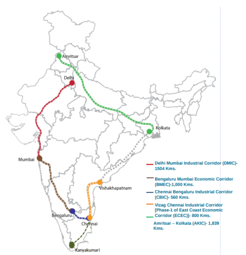
Main characteristics of industrial corridors
- Connectivity: typically located along major transport routes, such as highways, railways, and ports, to ensure easy access to markets and raw materials.
- Industrial clusters: promote the development of industrial clusters, with companies from related industries located in close proximity to each other.
- Infrastructure: They require the provision of basic infrastructure such as power, water, and telecommunications, as well as specialized infrastructure such as industrial parks and logistics hubs.
- Investment promotion: They offer various incentives to attract investment, such as tax breaks, subsidies, and streamlined regulatory procedures.
- Skill development: Industrial corridors may also include provisions for skill development and vocational training.
2017
Juno Mission of NASA help to better understand the origin and evolution of the Earth
- The mission is particularly interested in Jupiter's core, which is believed to be like the rocky cores of the inner planets, including Earth.
- By studying Jupiter's gravity and magnetic field, Juno can help scientists understand how planets form and how they evolve over time.
- It could help scientists understand how Earth's magnetic field is generated and how it protects us from harmful solar radiation
- The mission is also looking for evidence of water and organic molecules in Jupiter's atmosphere, which could provide clues about the conditions that led to the formation of Earth.
Adverse environmental impacts of coal mining
- Significant contributor to environmental degradation - including air and water pollution, deforestation, and greenhouse gas emissions
- Land degradation – coal mines
- Coal as a fuel causing global warming
- Coal with high carbon content is abundantly available – coal mining and thermal plants are well developed.
- Affordable energy to support economic growth– particularly for India with high poverty and developmental priority
- Demand for coal in Iron and steel industry
- Belief that improvements in technology and regulation can help mitigate the environmental impact of mining – e.g. coal-gasification, imposing carbon tax in India
Advantages of cultivating pulses
- Nutritional Benefits: excellent source of protein, fibre, vitamins, and minerals - low in fat and cholesterol
- Environmental Benefits: fix atmospheric nitrogen, which makes them a natural fertilizer - reduces need for chemical fertilizers
- Economic Benefits: Pulses are an important crop for many small farmers around the world. They provide a source of income and food security, especially in developing countries.
- Food Security: Pulses are a key part of a healthy diet and can help to reduce malnutrition and hunger.
- Climate Change Mitigation: Pulses have a low carbon footprint and require less water.
- Agricultural Productivity: Pulses are important plant in crop rotation and inter-cropping – increase productivity of the other crop.
Effects of cryosphere on global climate
- Snow and ice act as important reflector of sunlight (albedo) – essential for regulating earth’s temperature and energy balance. As snow melt, earth becomes darker causing global warming.
- When ice melts in the Arctic, it releases freshwater into the ocean, which can affect the ocean's salinity and temperature, potentially changing the direction and strength of ocean currents.
- The melting of the cryosphere also contributes to sea-level rise, which has the potential to affect coastal areas and human settlements.
- Thawing permafrost can release large amounts of greenhouse gases, further exacerbating global warming.
- Helps cooling the air. Eg.: the cold Labrador current originate from cryosphere and influence climate of eastern coast of North America.
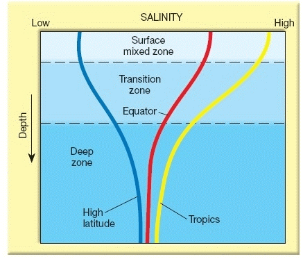
Variations in oceanic salinity
- In areas where there is high evaporation and low rainfall, such as in the tropics and subtropics, oceanic salinity tends to be highest.
- Salinity also varies with increasing depth
- Conversely, in areas where there is high rainfall and low evaporation, such as in the equatorial regions, salinity tends to be low.
- In coastal regions, flow of river water into ocean reduces salinity.
- Polar and sub polar zones have minimum salinity due to low evaporation and fresh water supply from melting ice.
- Winds are responsible for movement of ocean water as currents that cause change in salinity.
 Multi-dimensional effects of variation in oceanic salinity
- Distribution of ocean currents is largely determined by variations in oceanic salinity.
- The salty water in the subtropics is denser than the less salty water in the equatorial regions. This density difference drives the global thermohaline circulation, which plays a crucial role in transporting heat around the planet.
- Variations in salinity can alter the solubility of certain minerals and nutrients, which can impact the growth of phytoplankton and other primary producers.
- Changes in oceanic salinity can affect the distribution and abundance of fish species, which can have economic and ecological implications.
Positive Implications of Refineries away from oil-wells
- Refineries tend to be situated closer to markets - helps in saving transport costs as transport costs of refined products tends to be higher than transporting crude oil as they lose weight through evaporation during transporting.
- By-products generated during the refining process are very useful in industries like chemical, pharmaceutical, fertilizer, etc.
- It helps in additional employment generation and economic development in a particular region.
- Refineries near the ports enable a country to export the oil to other nations- help in foreign exchange earnings
- Oil field can be exhaust in future, but market can last for a longer period. Thus, establishing refinery near to consuming market helps in optimal utilization of capital-intensive infrastructure.
- The transportation of crude oil to large distances will increase environmental pollution and costs.
- If the refineries and the crude oil-producing areas are in different states it may create conflict.
- An abandoned oil-producing area doesn’t attract other industrial investments.
The unique characteristics of the monsoon climate
- Seasonality: During the summer months, warm and moist air from the ocean is drawn inland, leading to heavy rainfall that is critical for agricultural production. This allows farmers to cultivate crops such as rice, wheat, and corn, which are major sources of food for the population. The monsoon rains also replenish water resources, which are essential for drinking, irrigation, and hydroelectric power generation.
- Variability: The timing, intensity, and duration of the monsoon rains can vary significantly from year to year, which can pose challenges for agricultural production and food security. However, the monsoon climate has also fostered a unique agricultural system that is adapted to its variability. Example, farmers in India and other monsoon regions practice multiple cropping, which involves planting several crops in the same field to take advantage of different monsoon patterns.
- Influence on cultural and social traditions: Festivals and rituals are often tied to the monsoon season, celebrating its arrival and its role in sustaining life. The monsoon climate has also shaped the architecture, with features such as sloping roofs and courtyards designed to manage monsoon rainfall.
Methods to convert floods into sustainable source of irrigation and all-weather inland navigation
Sustainable source of Irrigation:
- Construction of small-scale storage and diversion structures - capture excess water during floods and store it for use during the dry season.
- Promotion of water-efficient farming practices from these flood storage structures, such as drip irrigation and mulching.
- Interlinking of riversg. Kosi, Gandak and Son, to divert flood water from one river to next – thereby regulating floods as well as provide water for agriculture.
- Traditional water diversion methods: g. Ahar or Pyne in Bihar, Khuls in Himachal Pradesh - rejuvenated to divert flood water.
- Developing waterways and river transport systems - facilitate the movement of goods and people. E.g. National Waterway-1 project on the Ganges River.
- Dam Management: release of flood water in a phased manner for regular supply of water to rivers. E.g. Narmada river using Sardar Sarvovar Dam
- International experiences: Tennessee Valley Project - A system dams and locks aids in maintaining adequate water level.
- Flood mapping: study to chart navigation routes
By the above methods, floods can be converted into a sustainable source of irrigation and all-weather inland navigation and help improve agricultural productivity, reduce transportation costs, and enhance the resilience of communities to floods and other climate-related hazards.
Positive effects of growth of cities as I.T hubs
- IT hubs created skilled jobs. E.g. Data analytics, BPO, electronics hardware etc.
- Brought in investments (FDI) and indirect jobs in IT hubs with better pay.
- Engineering colleges sprouted to meet the labour demands of IT industry.
- Urban sprawl - Many IT companies are in suburban or semi-urban areas, which has led to the expansion of cities and the creation of sprawling suburbs - resulted in overcrowding, loss of agricultural land etc.
- Traffic congestion lack of adequate public transportation infrastructure - negative impact on air quality, as well as people's quality of life. E.g. Bangalore traffic problems
- Environmental degradation – concrete structures destroy ecosystems – cause water pollution, urban heat-islands, e-wastes. E.g. water quality issues in Noida.
- Social inequality - The high salaries offered by IT companies can lead to rising housing prices and rents, which can make it difficult for low-income families to afford housing – leads to displacement and social fragmentation.
- Increasing crime rates - Shortage of resources like water, overcrowding, higher poverty rates, unemployment, and a loss of social services and education causes violence, drug misuse etc.
2016
They are classified based on their temperature and moisture content, into 5 types - continental Arctic (cA), continental Polar (cP), continental Tropical (cT), maritime Polar (mP) maritime Tropical (mT)
Role of air masses in macro-climatic changes over a large area.
- When air masses with different characteristics (e.g., temperature and moisture) meet, they can create weather fronts, which are boundaries between different air masses.
- This can result in a range of weather conditions, including extra-tropical cyclones, thunderstorms, rainfall, and changes in temperature and humidity.
- Cold air masses create high pressure and stability conditions in temperate and sub-tropical regions
- Air masses are moved by prevailing winds, such as the trade winds, westerly, and polar easterlies - transport air masses across large distances, influencing weather patterns and climate over vast regions.
E.g.: The movement of warm, moist air masses from the equatorial regions towards the poles is responsible for the development of the tropical rainforests and temperate regions.
Causes of landslides in the Himalayas
- Geological factors - unstable nature of the mountains, tectonic activities, and the presence of weak geological formations.
- Climatic factors - heavy rainfall, snowmelt, and earthquakes can also trigger landslides.
- Human activities - deforestation, mining, road construction, and unregulated urbanization can exacerbate landslides by destabilizing slopes and altering the natural drainage patterns.
- Early warning systems: use of modern technology such as satellite imagery, remote sensing, and ground-based sensors.
- Slope stabilization measures: retaining walls, gabion walls, and soil nailing can help to reduce the risk of landslides.
- Reforestation: Planting trees and restoring natural vegetation to stabilize slopes
- Land use planning: preventing construction in areas prone to landslides and regulating mining and road construction - prevent overgrazing, practice contour farming.
- Education and awareness: Educating communities about the risks of landslides and how to prepare for and respond to them.
Proper management of land resources drastically reduce the human miseries
- Sustainable land-use practices such as conservation agriculture, agro forestry, and sustainable grazing systems.
- Efficient crop planning and crop rotation can lead to improved fertility of the soil
- Cooperative farming can lead to better productivity from the same land, increase rural incomes, and alleviate the miseries of small and marginal farmers
- By adopting such practices, it is possible to increase crop yields, improve soil fertility, and protect the environment from degradation.
- Water conservation, recycling, and reuse, and the promotion of sustainable water use practices such as drip and sprinkler irrigation increase water use efficiency.
- Instead of big hydro-projects, small check-dams, and measures such as rainwater harvesting and storm water management can lead to greater availability of water, alleviating water woes.
- Proper water management can help to ensure that water resources are available for drinking, irrigation, and industrial use, reducing the incidence of water scarcity and improving human well-being.
The South China Sea (SCS) is a critical waterway that links the Pacific and Indian Oceans and is of great geopolitical significance.
Geopolitical Significance of South China Sea
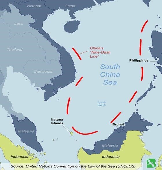
- One of the busiest shipping lanes - one-third of global trade, including oil and gas shipments.
- Rich in fishery resources and potentially significant oil and gas reserves.
- Overlapping territorial claims by China and several Southeast Asian nations, including Vietnam, the Philippines, and Malaysia.
- China claims almost the entire SCS, including areas that are recognized as belonging to other countries under United Nations Convention on the Law of the Sea (UNCLOS).
- China has been building and militarizing artificial islands in the SCS, raising concerns. E.g. Mischief Reef, Subi Reef.
- US has been conducting freedom of navigation operations to challenge China
- The region is home to several disputed island chains, such as the Paracels and the Spratlys, which are also claimed by other countries in the region.
Factors contributing to urban floods
- Urbanization: proliferation of concrete structures, which are unable to absorb rainwater - causes water logging and flooding.
- Encroachment of natural water bodies: Reducing ability of lakes, ponds, and wetlands to absorb excess water. E.g. encroachment of Lake Adyar Chennai caused floods
- Poor drainage infrastructure: Unable to handle the volume of water generated during heavy rainfall. E.g. Mumbai floods due to lack of separate storm drain.
- Climate change: Increased precipitation and more extreme weather events, making cities even more vulnerable to flooding. E.g. higher sea levels caused larger tides in Mumbai – sea-water returned to the city.
- Inadequate disaster preparedness: Difficult to respond effectively in the event of a flood.
- Developing green infrastructure: such as parks and green roofs, to absorb excess rainwater.
- Restoring natural water bodies: increase their capacity to absorb excess water during the monsoon season.
- Upgrading drainage infrastructure: separate storm and sewage drains – regular de-silting.
- Building flood resilience: Disaster preparedness plans and community’s community awareness.
Treaty divides the Indus River system into two parts, with India receiving control over the eastern rivers (Sutlej, Beas, and Ravi), while Pakistan receives control over the western rivers (Indus, Jhelum, and Chenab).
Implications of Indus Water Treaty in the context of changing bilateral relations
Ecological perspective
- Cooperation in Tran boundary Water Management: Changing bilateral relations could affect the level of cooperation, potentially impacting joint efforts in transboundary water management, including data sharing, flood management, and environmental protection.
- Climate Change and Water Availability: changes could affect in addressing the challenges posed by climate change on water resources
- Irrigation and Agriculture: The availability of water for irrigation directly impacts agricultural productivity, food security, and the rural economy in both countries
- Hydropower Generation: The allocation of water for hydropower generation has economic implications in terms of energy security, electricity production, and revenue generation through the sale of surplus power.
- Confidence-Building Measure: The treaty has served as a confidence-building measure between India and Pakistan.
- Diplomatic Tool: It provides a platform for dialogue and negotiations on water-related issues and allows for the resolution of disputes through bilateral mechanisms, such as the Permanent Indus Commission.
- Scope for Cooperation: The treaty provides an opportunity for India and Pakistan to engage in cooperative efforts for the sustainable management of water resources.
Problems of inland water transport in India
- Insufficient infrastructure: such as ports, terminals, and navigational aids are inadequate.
- Limited navigability: Many of the rivers in India are not navigable throughout the year due to low water levels, sandbars, and seasonality.
- High operational costs and limited availability of vessels: Leading to higher freight rates compared to other modes of transport.
- Limited availability of vessels: Leading to a lack of competition and inadequate capacity to meet demand.
- Cost-effective: for bulk cargo movement, particularly for heavy goods such as coal, iron ore, and cement.
- Environmentally friendly: compared to road and rail as it emits lower carbon emissions and has a lower carbon footprint.
- Reducing road congestion: IWT can help reduce road congestion and save on transport costs, especially in urban areas where traffic congestion is a major problem.
- Potential for tourism: India's vast network of rivers provides ample opportunities for the development of river tourism and recreational activities.
- Government interventions: Declaration of National Waterways, “Sagarmala Project”, Multi-modal ports
Micro-watershed Development projects help in water conservation in drought prone and semi-arid regions of India
- Soil and water conservation: through measures such as contour bunding, check dams, and trenches that help in conserving soil and water, preventing soil erosion and enhancing the groundwater recharge.
- Agro forestry: These projects promote the planting of trees and shrubs, which helps in soil conservation, improves soil moisture, and creates a conducive environment for the growth of crops.
- Efficient water use: projects such as drip irrigation, water harvesting, and the use of water-efficient crops helps in maximizing the use of available water resources and minimizing wastage.
- Rejuvenation: of natural reservoirs, wells and tanks – helps raise groundwater level.
- Community participation: who are trained in water conservation techniques and are involved in the planning and implementation of the project - creates awareness and sense of ownership.
2015
Factors for origin of ocean current
- Insolation - causes the water to expand -This causes a very slight gradient and water tends to flow down the slope.
- Wind: creates friction that drags the seawater and generates currents - cause the ocean to move in a circular pattern, creating gyres.
- Temperature: influence density of the water, causing it to sink or rise.
- Earth's rotation: causes Coriolis effect - currents in the Northern Hemisphere to move in a clockwise direction.
- Help to distribute heat around the world's oceans.
- Cold ocean currents cause formation of desert type climate in western regions of tropical continents.
E.g.: Canaries Current cause Sahara Desert. - Warm Ocean currents causes rainfall and moderating effect
E. g.: North Atlantic drift moderating effect in Britain.
- Ocean currents help distribute nutrients. E.g. Upwelling of Peru current.
- Major fishing zones are located at the meeting point of warm and cold currents.
E.g.: Grand Bank at the meeting of Gulf Stream and Labrador Current.
- Ocean currents can either assist or hinder ships, depending on the direction and strength of the current.
- Ships can use ocean currents to save time and fuel by travelling in the same direction as the current.
Significances of discovery of oil in Arctic Sea
- Oil and natural gas could be exploited to provide a new source of energy for the world.
- Bring significant economic benefits to the countries including Russia, Norway, Canada, and the United States.
- This could include job creation, increased investment, and greater revenues from the sale of oil and gas.
- Affect global oil and gas prices - reduce reliance on middle East
- New shipping routes through Arctic – reduce travel time and costs
- The region is home to a fragile and unique ecosystem, Arctic permafrost, and oil spills or other accidents could have catastrophic effects on the environment and the wildlife that live in the area.
- Extraction of fossil fuels could exacerbate the impacts of climate change like sea level rise, carbon release.
- Geopolitical consequences, as countries compete for control of the region's resources
Reason for more air pollution in Delhi in comparison with other megacities
- Geography: Delhi is situated in a landlocked region, and it is surrounded by agricultural fields and industrial areas that contribute significantly to air pollution. E.g. Stubble burning in nearby states.
- Climate: Delhi also experiences temperature inversions during the winter season, which can trap pollutants close to the surface, leading to high levels of air pollution. Delhi experiences frequent dust storms contributing to particulate matter in the air.
- Particulate emissions: Delhi has a high density of vehicles on its roads, higher use of fossil fuels and high construction activities, and burning of bio-mass - contribute to higher particulate emissions.
- Poor pollution control measures in Delhi. E.g.: the odd-even rule and the ban on the use of firecrackers during Diwali has not been effective.
India is well endowed with freshwater resources
- Rivers: India has several major rivers, including the Ganges, Brahmaputra, Yamuna, Godavari, Krishna, and Narmada, among others
- Lakes and Wetlands: India has numerous lakes and wetlands, both natural and man-made. E.g.: Dal Lake in Kashmir, Chilika Lake in Odisha
- Monsoon Rainfall: India's freshwater resources are largely dependent on the monsoon rainfall.
- Surface run-off: India receives majority rainfall in 3-4 months of Monsoon. Considerable portion is lost as water vapour and surface run-off.
- Unequal distribution of water resources: Some regions having an abundance of water (E.g. North and east India) while others (West and south) suffer from acute water scarcity due to less rainfall and have limited water resources.
- Population growth: Puts pressure on the available water resources, leading to overuse and depletion.
- Inefficient use of water: Irrigation systems (e.g. flood irrigation for paddy, tube wells) are often outdated and inefficient, resulting in the wastage of water. Poor conservation and recycling of water Industries and households.
- Climate change: Leads to more frequent droughts and floods - exacerbates water scarcity
- Pollution: Many rivers and lakes contaminated with industrial waste and sewage – makes water unsuitable.
Tourism and how it impacts carrying capacity
- Activities such as trekking, camping, and adventure sports in these states has led to soil erosion, deforestation, and habitat destruction.
- Unplanned construction, heavy traffic, poor waste disposal, overcrowding has affected the ecological resilience of the region.
- Tourism can lead to the displacement of local communities and the loss of traditional livelihoods. Loss of cultural heritage due to the commercialization of cultural practices.
- Floods in Uttarakhand and Jammu & Kashmir has pointed fingers at unsustainable tourism practices.
Way forward
- It is crucial to involve local communities in the decision-making process, and to ensure that the benefits of tourism are shared equitably.
- Sustainable tourism practices, including responsible tourism, ecotourism, and community-based tourism, can help to mitigate the negative impacts of tourism and promote sustainable development.
- Measures such as carrying capacity assessments, environmental impact assessments, and regulatory frameworks can help to manage tourism development and ensure that it is sustainable and socially responsible.
Changing monsoon patterns
- Surplus precipitation: Central and southern India saw a sharp surge in rainfall.
- Deficit: On the other hand, large parts of U. P., Bihar, Odisha have seen large deficits.
- Incessant rain over Delhi and several other parts of North and Northwest India
- Fewer rainy days but more intense rain
- Deforestation: reduces the ability of the land to absorb and retain water, leading to increased runoff and soil erosion - can alter the timing and intensity of rainfall.
- Urbanization: other land-use changes can also affect the microclimate of the region, which can impact the monsoon.
E.g. encroachment of water-bodies. - Agricultural practices: Excessive irrigation makes land surface wet before monsoon – weakens the low pressure necessary for monsoon to progress.
- Global warming: Human induced global warming accelerates snow melting in the Himalayan glaciers. This disrupts the intensity of Tibetan low-pressure that attracts the monsoon to Indian subcontinent.
- Calamities: Construction of mega dams in fragile mountainous areas invites flash flooding during monsoons. E.g. Uttarakhand flash-floods (2013)
- Emissions: particulate matter and aerosols disrupt the cloud formation during and before monsoons.
Smart cities in India cannot sustain without smart villages
- Resource: One of the major reasons for this is that rural areas in India are the primary source of food and other resources that urban areas require.
- Infrastructure deficit: The lack of development in rural areas leads to a significant urban-rural divide, resulting in disparities in the standard of living and a burden on urban infrastructure.
- Healthcare: Poorly developed health care in villages resulting in burden on urban hospitals as villages doesn’t have secondary and tertiary health care.
- Unorganised sector: Most of the migrant workers with low or semi-skills end up in unorganised sector jobs like construction works resulting in poor wages and growth.
Integration of Rural-Urban Areas
- Moreover, rural-urban integration can create a balance between the two areas, reducing the stress on urban infrastructure and easing the pressure on resources.
- With the development of smart villages, the migration of people from rural to urban areas can be controlled - provide opportunities for people to stay in their own villages and work.
2014
Unusual climatic happenings: an outcome of the El-Nino effect.
- The effects of El Nino in South America are direct and stronger. Because of El Niño, increased rainfall occurs across the east-central and eastern Pacific Ocean. Along the coasts of northern Peru and Ecuador, major flooding is caused by El Nino. The local fishing industry can suffer during long-lasting El Nino events.
- Areas west of Japan and Korea tend to experience much fewer tropical cyclone impacts during El Nino and neutral years.
- Unusual droughts in Australia have also been associated with the effect of El Nino.
- El Nino's effects on Europe appear to be strongest in winter and make the region colder.
- The tropical Atlantic Ocean experiences depressed activity due to increased vertical wind shear across the region during El Nino years.
67) Why are the world’s fold mountain systems located along the margins of continents? Bring out the association between the global distribution of fold mountains and the earthquakes and volcanoes. (200 words)
Location of fold mountains
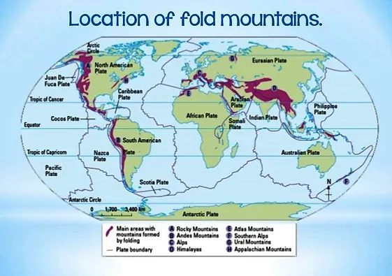
- In Continent-Continent (C-C) convergence, oceanic sediments are squeezed and up thrust appear as fold mountains along the plate margins. g. Himalayas (Eurasian plate and Indo-Australian plate), Alps (African and Eurasian Plate).
- In Continent-Ocean (C-O) convergence, the continental volcanic arc formed along the continental plate margin is compressed and is uplifted by the colliding oceanic plate giving rise to fold mountains along the continental plate margin.
E.g. the Rockies (North American and Pacific Plate), Andes (South American and Pacific Plate)
- When tectonic plates collide, they can create enormous stresses that can lead to earthquakes, because of the sudden release of friction between the subducting plate and up thrust plate.
- Volcanism is observed only in C-O convergence and is almost absent in C-C convergence. In C-O convergence, metamorphosed sediments and melting of the subducting plate form magma which escapes to the surface through the less thick continental crust
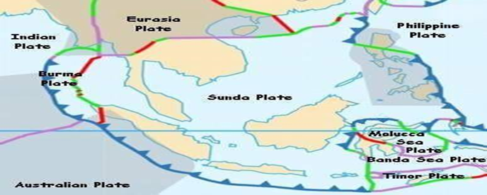
The formation of the thousands of islands in Indonesian and Philippines archipelagos
They are primarily due to two geological processes: volcanism and plate tectonics.
Volcanism:
- The Pacific Ring of Fire is home to many active volcanoes, and the eruption of lava and other volcanic materials can create new land masses.
- Over time, repeated volcanic activity can result in the formation of large islands.
- The region is located at the boundary of several tectonic plates.
- When two plates collide, one plate is typically forced under the other, creating subduction zones where the plates interact.
- This can lead to the formation of volcanic arcs, where magma rises to the surface and creates new islands.
- Indonesian archipelago was formed due to convergence between Sunda oceanic plate (part of the Eurasian plate) and Indo-Australian plate whereas Philippine archipelago was formed due to convergence between Sunda oceanic plate and Philippine Sea plate.
Change in the spatial pattern of the Iron and Steel industry in the world
- Early 20th century, the industry was concentrated in Western Europe and the United States -driven by the availability of raw materials, such as coal and iron ore, and the development of new technologies.
- Latter half of the 20th century, the industry shifted to other regions - East Asia and Latin America. Due to globalization, the emergence of new markets, and changes in the cost of labour and transportation.
- In the 1970s and 1980s, Japan emerged as a major player in the iron and steel industry, driven by its highly skilled workforce, advanced technology, and access to raw materials. Other East Asian countries, such as South Korea and Taiwan, also established strong steel industries during this period.
- In the 1990s and 2000s, China emerged as the world's largest producer of steel, driven by its massive workforce, low labour costs, and massive investments in infrastructure. Other countries in the region, such as India and Vietnam, also saw significant growth in their steel industries during this time.
Various resources which can be Harnessed
- Fish and other seafood - valuable source of protein and support a global industry.
- However, overfishing, and unsustainable practices have led to declines in many fish populations and threatened the health of entire marine ecosystems.
- Renewable energy, including wave and tidal power - significant amount of power to coastal communities and reduce reliance on fossil fuels.
- However, there are concerns about the impact that these technologies could have on marine ecosystems and local communities.
- Minerals and other resources - including oil, gas, and rare earth metals – manganese nodules contain iron, cobalt, nickel etc.
- However, the extraction of these resources can be costly and often has significant environmental impacts, including oil spills and damage to sensitive marine habitats.
- Warm sea surface temperatures
- Coriolis force to sustain a low-pressure centre
- Unstable atmospheric condition
- High humidity in low atmosphere
- Low vertical wind shear, which is the change in wind speed and direction with height.
Reason for larger confinement of tropical cyclones in South China Sea, Bay of Bengal and Gulf of Mexico
- Warm ocean waters: The above regions are all located in regions where ocean temperatures are warm enough due to the surrounding land.
- Low vertical wind shear: The above are regions where wind shear is generally low, which allows storms to form and strengthen.
- Location closer to Inter Tropical Convergence Zone (ITCZ): Thus, the north-east and south-east trade winds meet helps push the lower-level winds for rotation.
- Atmospheric conditions: The above regions are characterized by high humidity and unstable atmospheric conditions.
Symptoms of climate change include the rising temperatures, sea levels, occurrence of natural calamities like draught and floods, changing weather patterns like rainfall etc.
Relationship between shrinking Himalayan glaciers and climate change in the Indian sub-continent
- Rising temperatures causes accelerated melting of glaciers. Vanishing glaciers reduces earth’s heat reflectivity (albedo), causing more heat absorption further increasing melting.
- As ice-cover reduces more water and land is exposed – this increases evaporation negatively affecting water supply for communities in Indian subcontinent that rely on glacier melt for freshwater needs.
- Shrinking of glaciers increases the risk of landslides and glacial lake outburst floods and other calamities.
- Loss of glaciers disrupts monsoon weather and cause water scarcity – symptoms of climate change – impact agriculture and food security in Indian subcontinent.
- Increased glacial melt can increase sea levels and change hydrology of Himalayan rivers like Ganga, making them seasonal.
Reason for no expansion of British tea plantation beyond Darjeeling area
- Altitude and Climate: The tea plant requires a specific set of conditions to grow, including cool temperatures and high humidity. While the foothills of the Himalayas (Assam and Darjeeling) provide these conditions, the higher altitudes beyond Darjeeling (Himachal, Doon valley, Ranchi etc) were not suitable for tea cultivation.
- Topography and Soil: Tea shrubs needs fertile mountain soil mixed with lime and iron. The rugged terrain and poor soil beyond Darjeeling made it difficult to establish and maintain tea gardens
- Economic factors: Cheap labour from nearby states of Bihar, Odisha, and Bengal. Easy transportation of tea due to road and river networks and sea-ports in Dhaka and Hooghly.
- Political Factors: Assam region was not politically charged like the main land so not much opposition to clearing forest lands.
Factors led to by-passing the eastern region of India despite fertile soil and good availability of water in Green revolution
- Lack of Irrigation Infrastructure in eastern states like West Bengal, Assam - difficult to expand agricultural production and implement the high-yielding crop varieties. Northern states had irrigation projects like Bhakra Nangal.
- Land Reforms: eastern region of India implemented land redistribution to landless farmers in the 1950s and 1960s - created a more equitable distribution of land, but also made it difficult to implement large-scale commercial agriculture.
- Recurrent floods in Rivers like Damodar, Mahanadi disrupted agriculture in eastern India.
- The political leadership in West Bengal at the time was opposed to the Green Revolution to maintain traditional farming practices and farmers welfare.
- North Indian farmers led by Punjab and Haryana were often exposed to new ideas and were first to adopt high yield variety seeds, fertilisers etc for commercial agriculture.
- Cooperative societies and peasant groups like Kisan Sabha in UP were missing in eastern India
India’s place in the economic space of rising natural resources rich Africa
- Energy: Africa provides opportunity of diversifying our energy sources, e.g.: Oil from Nigeria, given the instability and India’s over dependence on middle-East.
- Rising Africa offers opportunity for increasing trade and communication. Indian universities can welcome aspirational students from Africa.
- Investments: India has been increasing its investments in Africa, e.g. oil and gas, minerals, and agriculture, infrastructure development, such as ports and railways, to facilitate trade and commerce between the two regions.
- Diplomacy: Engaging in regular high-level meetings for cooperation, such as the India-Africa Forum Summit.
- Support: India has also offered technical and financial assistance to African countries to support their development efforts. E.g.: technology transfer, line of credit
India's long-standing cultural and historical ties with Africa and its commitment to sustainable and inclusive development have helped to differentiate it from other players in the region and India is working to deepen its economic and diplomatic ties with the continent to advance its strategic interests and contribute to Africa's sustainable development.
2013
76) a) Bring out the causes for more frequent occurrence of landslides in the Himalayas than in the Western Ghats. (100 words)
b) There is no formation of deltas by rivers of the Western Ghats. Why? (100 words)
Causes for more frequent occurrence of landslides in the Himalayas than in the Western Ghats
- Altitude and slope: The Himalayas are much higher in altitude than the Western Ghats, and the steep slopes make them more prone to landslides.
- Seismic activity: The Himalayas are young fold mountains and therefore in an earthquake-prone region – triggering soil instability and landslides.
- Snow: Himalayas are snow covered, which aids landslides
- Rivers: Himalayan rivers are perennial, carrying greater amount of eroded material than its western counterpart
- Rock system: Himalayas are made of sedimentary rocks, which are easily erodible than western Ghats.
- Anthropogenic interventions: Human activities such as deforestation, dam building, road construction, mining, and logging have increased the risk of landslides in the Himalayas.
Reason for no formation of deltas by rivers of the Western Ghats
- Hard rock formation: The Western Ghats are primarily made up of hard rock formations, which are not easily eroded - the rivers (E.g. Narmada, Tapti etc) in the region do not have enough sediment to deposit and form deltas.
- High rainfall: The Western Ghats receive high levels of rainfall, which washes away the sediment before it can be deposited and form deltaic deposits.
- River flow: The rivers in the Western Ghats have a rapid flow, which makes it difficult for the sediment to be deposited and form deltas.
- Small streams: West flowing rivers of Western Ghats are generally small streams, flowing from steep slopes covering very short distance. They can form estuaries and not deltas.
77) a)Do you agree that there is a growing trend of opening new sugar mills in southern States of India? Discuss with justification.
b) Analyze the factors for the highly decentralized cotton textile industry in India.
Reasons for trend of opening new sugar mills in southern States
- Abundance of sugarcane: The southern states of India have abundant sugarcane production, making it an attractive location for the establishment of sugar mills.
- Climate: The tropical climate (higher rainfall and lower temperature) of south India supports the growth of the sugarcane – higher production per unit area.
- Sucrose content: higher sucrose content and longer crushing compared to north India
- Formation of cooperative societies favoured growth of sugar mills.
- Stable political environment and government support
- Increasing demand for sugar: With the growing population and rising standard of living particularly in the south.
Factors responsible for the highly decentralized cotton textile industry in India
- Availability of raw materials: Cotton is widely grown in India, making it easy to access raw materials for the cotton textile industry.
- Labour: India has a large pool of skilled and cheap labour, making it an attractive location for textile production.
- Lack of government control: The government has not imposed strict regulations on the textile industry, allowing for decentralized growth and development.
- Widespread market: The demand for cotton textiles has been growing in India and globally, driving the growth of the industry.
- Finished products: light-weight finished products helps in easier transportation thought India.
78) a) What do you understand by the theory of ‘continental drift? Discuss the prominent evidences in its support. (100 words)
b) The recent cyclone on east coast of India was called ‘Phailin’. How are the tropical cyclones named across the world? Elaborate. (100 words)
Evidences for Continental Drift Theory
- Fossils: The same types of fossils have been found on different continents, E.g. remains of extinct Mesosaurus, found solely in Southern Africa and Eastern South America.
- Jig-Saw-Fit: The shorelines of Africa and South America facing each other match remarkably.
- Placer Deposits: Source of placer deposits of gold in the Ghana coast found in Brazil plateau
- Tillite: The glacial tillite found in Gondwana system of sediments has its resemblance to six different landmasses of the Southern Hemisphere.
- Plate tectonics: helps explain how the continents move and provides a mechanism for the movement of the continents over time.
b) Cyclones are named by five regional bodies of World meteorological organization (WMO), Regional Specialized Meteorological Centers for their respective regions.
Naming of tropical cyclones
- Each of them is free to prepare the list of names and rules. Some rotate the list while some alternate names between boy and girl.
- North Indian Ocean region, the regional body headquartered at Indian Meteorological dept (IMD), New Delhi maintains the list of names suggested by member countries. Final name is assigned in chronological order of the occurrence
E.g.: Mahasen (Sri Lanka), Phailin (Thailand) and Helen (Bangladesh) in 2013. - Locally known short names are preferred for easy communication. Names associated with famous person or religion are avoided.
- If a Cyclone causes extensive damage, its name is struck off the list so it cannot be used again
E.g.: Katrina.
79) a) Bring out the causes for the formation of heat islands in the urban habitat of the world. (100 words)
b) What do you understand by the phenomenon of ‘temperature inversion’ in meteorology? How does it affect weather and the habitants of the place?(100 words)
Causes for the formation of heat islands in urban habitat
- Land Use Changes: The conversion of natural land to urban areas increases heat-absorbing surfaces, such as buildings, roads, and pavements, which trap heat.
- Human Activity: such as transportation and industry, release greenhouse gases into the atmosphere
- Lack of Vegetation: which would otherwise provide shade and help cool the environment.
- Waste Heat: The use of air conditioning and heating systems release waste heat into the atmosphere.
- Urban Canopy Layer: layer of air close to the ground in an urban area, is often warmer than the air above it due to the trapping of heat by the built environment.
b) Normally temperature decrease with height. But when a layer of cool air is trapped near the ground by a layer of warm air, preventing it from rising and mixing with the surrounding air – it causes temperature inversion.
It commonly occurs in mountain valleys. long nights, open sky and clear air facilitate this phenomenon.
Effects on Weather
- Fog: When warm air condenses rapidly over underlying cold air.
- Smog: when fog is mixed with pollutants.
- Frost: when warm air gets condensed below freezing point.
- Atmospheric stabilitye., dry condition and no rain.
- Foggy conditions cause lower visibility, health hazards and crop failures.
- In Mountain valleys, factories, houses, and farms are located along the upper slopes rather than in lower valley.
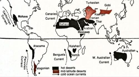
Reasons for Location major Hot Deserts in western side of the continents
- The subtropical high-pressure zones, also known as the Hadley Cells, are located around 20-30 degrees North and South latitude - characterized by descending air, which leads to high pressure, clear skies, and low humidity, creating the conditions necessary for desert formation.
- The North East trade winds carry moisture from the warm oceans and cause intense rainfall on the eastern regions of the continents. However, when they reach the western side of the continents, they lose most of their moisture thereby causing arid conditions.
- Effect of ocean currents – cold ocean currents on the western margin of continents reduce the capacity of wind to hold moisture and reduce moisture availability. E.g. Canary Current on Western Africa
Availability of raw material required for the generation of atomic energy in India
- In India, there are significant reserves of uranium, which are primarily located Hazaribagh (Jharkhand), Tummalapalle (Andhra Pradesh), Udaipur (Rajasthan) and Mahadek basin (Meghalaya.
- The Indian government has been actively working to develop the uranium mining industry.
- India has also developed a program for the reprocessing of spent fuel from its nuclear power plants, which provides a reliable source of plutonium for the generation of atomic energy.
- large reserves of thorium in India (Malabar Coast)
- In the world, there are significant reserves of uranium in countries such as Kazakhstan, Canada, and Australia, which are major suppliers of uranium to India and other countries.
- There are also large reserves of thorium, which is another raw material used in the generation of atomic energy in countries such as Australia and the United States.
Major available Shale reserves in India
Cambay Basin, Krishna Godavari Basin, Indo-Gangetic Basin, Cauvery Basin, Assam-Arakan Basin and Gondwana regions.
Issues with tapping the resources and availability
- The high cost of extraction through hydraulic fracturing – low infrastructure and technology.
- Fracturing requires large amounts of water and chemicals, which can be harmful to the environment
- Potential for groundwater contamination (methane poisoning) and the release of greenhouse gases into the atmosphere.
- Large water usage can pose challenges to agriculture and drinking water
- Shale formations are in human settlements posing a major obstacle in extraction - risk of widening economic and social inequalities and land issues.
- Coal bed methane reserves are estimated to the 5 times the shale led to shift in priority
- Government guidelines on maintaining a distance between the aquifers and the shale gas fracture zones to regulate water contamination.
- Brining in private investments and international collaborations for reducing cost of extraction.
- Shale gas policy that takes into perspective the land use, water extraction and emissions.